Campi Flegrei Volcano
Contains adsIn-app purchases
10K+
Downloads

Everyone
info
About this app
Developed by an independent volcanologist this app allows you to follow in near-real-time the shallow volcanic earthquakes at Campi Flegrei volcano in Campania, Italy. Since 1950 the risk of an eruption of this volcano has been slowly increasing, representing an increase in potential volcanic hazard for more than 600,000 people living on its surface.
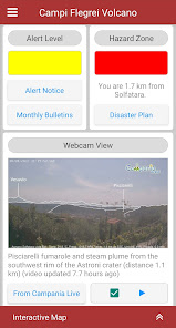
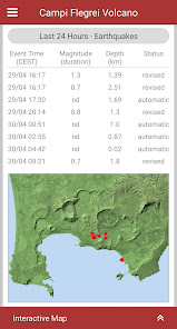
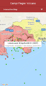
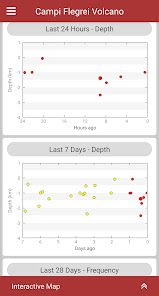
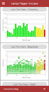
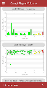
The earthquake data are obtained by the Vesuvius Observatory of Italy's National Institute of Geophysics and Volcanology (INGV) and published online in near real-time. This app regularly downloads these data and creates time-series graphs showing trends in earthquake frequency, magnitude and depth. Epicentres are also plotted on an interactive map together with maps of the official hazard zones and your location if you are in the area.
Designed for easy access to important volcanological data this app will appeal to residents and visitors who want to monitor any significant changes which might affect the eruption risk of Campi Flegrei. For residents in particular the app will quickly provide the details of any earthquakes you might feel.
(*The app is not associated with or endorsed by INGV. For official information on volcanic risk at Campi Flegrei visit https://www.ov.ingv.it).
Updated on
Safety starts with understanding how developers collect and share your data. Data privacy and security practices may vary based on your use, region, and age. The developer provided this information and may update it over time.


What's new
- minor bug fixes